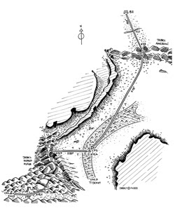
 2nd stage map B
2.1km: cross track, stony ground
3.8km: start of pass go S/SW (209)
4km: 1st Amessoui jebel crossing, cross the valley
4.8km:start of 2nd uphill section
5km: descend following the small path
5.5km: undulating terrain go S(188) to avoid the very stony ground until CP1
6.2km: flat terrain go SW until CP1
11.4km: CP1 on the banks of the Tijekht wadi, go W (282) until the foot of the jebel
13km: deceptively flat uphill section, slightly undulating
13.7km: climb up Hered Asfer jebel. Follow marked path over the crest then cross hilly ground
17.8km: go down into the valley a little way before the rocks in the form of a ruin
18.1km: go W/NW until CP2
20.3km: CP2 in the middle of valley, Go W until 22km
22km: cross the Rheris wadi going W/SW
22.6km: exit wadi, continue in same direction over flat terrain until CP3
24.2km: cross track
28.3km: hillock on the RHside
28.8km:CP 3 before El Otfal jebel. Go SW for a difficult uphill climb. 25% gradient on average until you reach the top
30.8km: top of jebel. Turn left for around 100m
30.9km: turn right to return to the wadi bed
31km: rocky wadi bed. downhill stretch
32.3km: end of downhill stretch in the wadi bed, cross the very stony plain
33.4km: enter dunes
34.7km: exit dunes
35.5km: arrive at bivouac


No comments:
Post a Comment